More than a bad rash: mapping the 1291/2 Taxatio in the Bayton area

Everybody loves a good map.

As part of my PhD thesis I’ve recently been making a bunch of national-scale distribution maps, comparing hoard findspots to other contemporary distributions – most obviously that of wealth, usually reflected in lay and ecclesiastical tax assessments. Britain, and England especially, is pretty well blessed with evidence of this sort. On the church front we’re definitely blessed by the University of Sheffield’s recently-beautified Taxatio Online database, the fruit of almost three decades’ work digitising Pope Nicholas IV’s 1291/2 tax assessment of English and Welsh benefices. The significance of this assessment has been justly recognised by historians for more than a century, not least because it remained the basis of parliamentary and convocation grants of the clergy well into the 16th century.[i]

In the course of converting this data into something mappable for my thesis, I was itching to check out what the Taxatio had to say about wealth – at least, of the church – in Bayton and its surroundings in the later Middle Ages. The obvious route was to look at the spatial distribution of tax assessed wealth using GIS mapping. The process from web database to pretty map is fairly smooth, but for the curious here’s a step-by-step walkthrough. Thanks to the nifty ‘Browse by County’ function it’s straightforward enough to extract data for the three counties in the study area – Herefordshire, Shropshire and Worcestershire – through a simple cut-and-paste job in Excel. At this stage a little data cleaning was necessary to clarify county attributions. Since Taxatio Online groups benefices by historic county, reattribution is necessary where modern county boundaries have shifted or where an attribution is otherwise historically incorrect; Bayton, for instance, has been historically a member of Worcestershire’s Doddingtree hundred, so it’s a little odd to find it chucked in as part of Shropshire. This complete, each benefice can be broadly spatially referenced via batch geocoding, and therefore importable into the GIS package of your choice. Unsurprisingly there are a couple of benefices listed which don’t yield an easy coordinate – some do not exist in the present day – and therefore some manual attributions were necessary, with the remainder given a quick double-check to make sure there were no obvious howlers in the spatial data. All in all this yielded coordinates for 535 benefices in the study area – not bad going!

Spatial bits thus recorded, the next main task was converting the assessment values – which Taxatio Online records as a £ s. d. value in a single cell – to a more uniform number amenable to analysis. The obvious solution is to convert everything into d. values; thus the assessment for Kinlet (Salop) changes from £ 10. 0s. 0d. to the simpler 2400d. A bit of Excel wrangling later and we have a .csv file ready to import as a vector in QGIS. All that was left was to load it up, do some styling, stick on top some boundary vectors and, hey presto, we have a map!
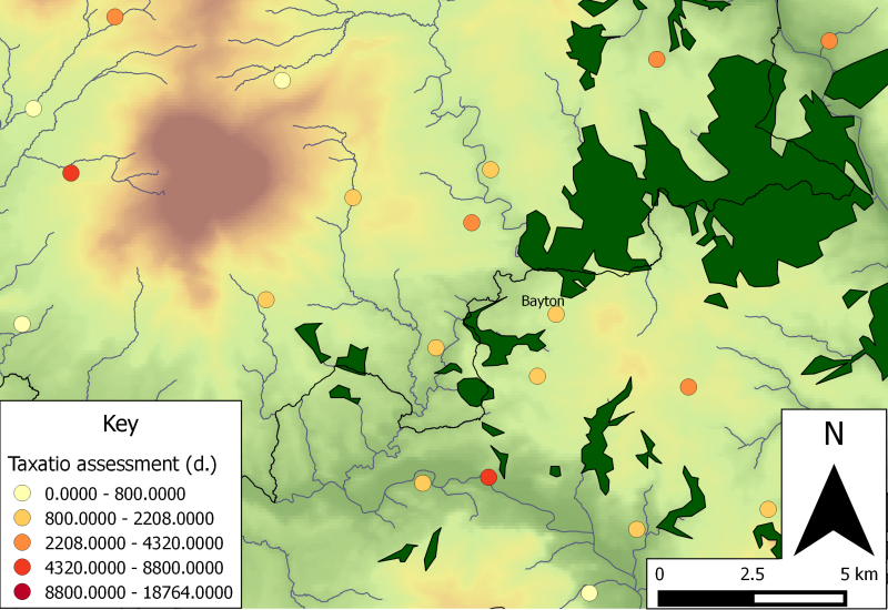
Taxatio assessments for NW Worcs/SE Salop in the later 13th century; the redder the dot, the higher the tax value ( Contains Ordnance Survey data © Crown copyright and database right 2014 and data available from U.S. Geological Survey).

Taxatio assessments for NW Worcs/SE Salop in the later 13th century; the redder the dot, the higher the tax value ( Contains Ordnance Survey data © Crown copyright and database right 2014 and data available from U.S. Geological Survey).

Chickenpox resemblance aside, the map gives some interesting glimpses of the distribution of church income in the region; since much of this was based on farmland tithes, it should offer some hints – albeit imperfect – to broader distributions of agrarian wealth in the region. What’s notable is the broad uniformity in which most of the benefices – including Bayton – fit, characterised by lower rung tax assessments of  £3 6s. 8d. to £9 4s. 0d. Poorer, certainly, than some of their cousins in the fertile arable of the Vale of Evesham, but by no means impoverished. Presumably the degree of uniformity reflects shared topographic characteristics conditioning local agrarian regimes across the area, but a note of caution against environmental determinism is given by the benefices at the foot of the Clee Hills – which includes Bitterley (Salop), whose value falls in the top 40% of assessed benefices, and Silvington (Salop), which was exempted by merit of its low income.

At the top end of the spectrum we can see a correlation between benefices with high tax assessments and the presence of a market. This is most obvious at Lindridge (Worcs), but can be observed beyond the map’s limits at Stottesdon (Salop), Kidderminster and Tenbury (Worcs). A link between the sites of formal marketplaces and areas of relative wealth comes as no surprise, and perhaps this is why the high values at Cleobury Mortimer (Salop) and Rock (Worcs) are so intriguing. Cleobury Mortimer was granted borough status in 1362, at which point we can presume it also acquired formal market rights, as Rock was to receive on 10 May 1328. Could the high tax assessments in 1291/2 indicate late 13th century markets formalised by subsequent charters? Excavations at Rock Farm offer a snippet of supporting evidence, yielding a medieval ceramic assemblage of 13th century and later date composed of both local and Malvernian wares produced c. 20 miles south east at the Hanley Castle potteries. Could some of this have arrived via the cross-county network of rural markets?[ii]

In itself the map raises a bunch of other questions. How much does the Taxatio reflect variations in ecclesiastical wealth alone, without taking into account the holdings of laypeople? Come to think of it, given the much-debated connections between population and wealth in this period, to what extent does the map inform us of broader issues of land, people and wealth during the ‘long’ 14th century? One route would be to map population and wealth as reflected in near contemporary lay tax records – most obviously the published 1327 lay subsidy returns for Shropshire and Worcestershire. Another project for another day?

[i] R. Graham, ‘The taxation of Pope Nicholas IV’, English Historical Review 23:91 (1908), 434

[ii] D. Hurst, “The finds,” in Evaluation at Rock Farm, Rock, ed. L. Fagan (Worcester: Hereford and Worcester County Council, 1993), 15.

The mystery of the missing maypole?

Back in the 1860s the antiquary John Noake penned a series of sketches of Worcestershire for the Birmingham Daily Gazette, republished in 1868 as a Guide to the county. Recounting his visit to Bayton, Noake drew attention to ‘a relic of old times…in the shape of a veritable Maypole’.[i]  As so often we’re indebted to Noake’s keen eye for this tantalising fragment of local heritage – there’s next to no trace of it in the present, and he seemed quite sure of its antiquity. So we’re justified to dig that little bit deeper – what can be said about the maypole, just how much of a ‘relic of old times’ was it, and why does it matter at all?

Tantalisingly terse - John Noake on the Bayton maypole

Tantalisingly terse – John Noake on the Bayton maypole

Somewhat paradoxically, going backwards necessitates going forwards – in this case to early 1887 when, with Queen Victoria’s Diamond Jubilee celebrations fast approaching, the parishioners of Bayton undertook to restore the village maypole. For around seven or eight years the wooden pole had lain unused and in disrepair, apparently because the family which could foot the bill for the festivities – the Wicksteads of Shakenhurst – had moved out of the area.[ii] The restoration efforts were evidently a success; the pole was back up in time for the year’s May Day celebrations, and the ensuing newspaper reports offer us some of the most detailed records we have for the revived custom. The day was a feat of organised quaintness:

  1.  In the early morning women and children started ‘wending their way towards the village carrying flowers and evergreens’, which they then tied onto garlands fastened onto the still-grounded pole;
  2. The flag was tied to the top of the pole, which was then heaved up by a group of men until it stood around 50ft in the air;
  3. The assembled crowd, which included the Mamble village band, performed patriotic songs and gave cheers for the Queen, the Vicar, and the Maypole, before breaking off into a dance.

After about an hour the crowd broke off, reassembling in the evening for more singing.[iii] The basic formula was repeated a couple of months later in time for the actual Jubilee – albeit then with the addition of food, sports, and the lighting of a beacon on Collier’s Hill.

The account reeks of twee Victoriana, probably because it is twee Victoriana – drenched in ‘Merrie England’ sentimentality and parochial romanticism, this is more Mary Berry than Medieval Bayton. Where it becomes more interesting is the claim that some parishioners had ‘helped to adorn the May-pole’ for 70 years, a fact independently verifiable in diary entries from 1801 onwards. So far so good – a terminus ante quem predating the wave of mid-Victorian revivalism, albeit still bearing the trademark gentry patronage of the revivalists. An earlier pedigree, however, was suggested by the eldest parishioners, who claimed that the pole had ‘been there long before them’.[iv] Assuming these claims were accurate, the custom of maypole rearing at Bayton is pushed back into the 18th century. Good stuff. Anything earlier?

Well, no. Anyone who studies vernacular culture has to make do with inadequate, incidental records, and in this part of Worcestershire the problem is amplified by the uneven survival of pre-18th century documentary evidence. Taken by itself, the evidence from Bayton would suggest that Noake’s ‘relic of old times’ wasn’t quite as old as he thought. Zooming out to the national scale, however, forces us to reconsider; the evidence of churchwarden accounts suggests that the rearing of maypoles, like many other May rituals, had been firmly rooted across southern Britain by the late 14th century, and early references can be traced in Worcestershire and Shropshire into the 17th century and earlier.[v] It’s therefore quite possible – likely, even – that the 19th century revellers were continuing a custom of later medieval precedent, albeit with much Victorian tat adhered to it. Importantly, however, we can’t yet prove it, mainly because we don’t have pre-19th century churchwarden accounts for Bayton or the nearby parishes of Mamble, Neen Sollars, Cleobury Mortimer, Lindridge, Rock or Pensax.[vi] Maybe something will turn up in future research, but maybe this is misplaced optimism. Some conjecture might not be amiss.

Stripped of the 19th century flags-and-flowers, we’re left with a big wooden pole standing in the village green.[vii] The evidence for its location is furnished by 20th century accounts and, importantly, the house name ‘Maypole Cottage’ on the east end of the green. No pre-19th century references can be found for this house name, although the building itself is a timber-framed structure of 17th century fabric – it may hint at earlier origins, or it may not. Either way, the monument would occupy a significant focal point in the local landscape visible from some distance. Its siting in the village green could be read as a metaphor for the significance of calendar customs in rural life; the ability of may rituals to ‘bring together’ otherwise fragmented rural communities would be expressed at the ideological and spatial levels. One poem in Corbett’s Poëtica Stromata, satirically addressed to the Vicar of Bewdley – around 6 miles due east of Bayton – gives us clues to visual appearances; ‘a Pole painted, and wrought…a lew’d Bird, towring upon the topp’.[viii] A post-medieval account, granted, but one which tallies with the gaudy decor so common to medieval monuments. Big wood implies trees, and the medieval parish had no shortage of woodland resources to draw on; one plausible source could be the extraparochial ‘Custom Wood’, a block of woodland in the Wyre Forest to which the parish had customary rights of housebote and timber, although many other sources are quite possible.

Speculation is indulgent and ultimately inconclusive, but serves to drag out a point; it’s quite plausible that the custom of maypole-rearing in Bayton was quite venerable indeed, perhaps even moreso than Noake had imagined. Despite Victorian reinvention, however, it was not to last. The maypole re-erected in 1887 was to be a permanent fixture in the village landscape into the early 20th century, featuring in the 1902 coronation celebrations of Edward VII; by the end of the decade, however, it had begun to rot, posing a danger raised at parish council meetings. At its AGM in April 1909 the parish council took the decision to remove the pole once the May Day celebrations were over, offering to cover any costs incurred by James Dunn, a local postmaster and grocer who had agreed to do the job free of charge. Execution was less than prompt, however, and a year later the rotting maypole was still standing on the village green awaiting replacement.[ix] Presumably before 1911 fresh wood had been found, when the council agreed – funds permitting – to organise a coronation party for the villagers of Bayton and Mamble, featuring ‘a meat tea for adults and tea with a souvenir of the coronation for children, also sports, bonfire and fireworks and raising of the May Pole’. It remained in the green as late as 1928, when Wedley could paint an idyllic picture of ‘the sports and pastimes of the England of long ago’.[x] Thereafter the trail darkens again – if anyone reading this knows about its fate, I’ll be pleased to hear it.


[i] J. Noake, Noake’s Guide to Worcestershire (London: Longman, 1868), 272

[ii] Worcester Chronicle, 7 May 1887, 5

[iii] Ibid.; Berrow’s Worcester Journal, 2 July 1887, 2

[iv] R. Judge, “May Day and Merrie England” Folklore 102:2 (1991), 135; Worcester Chronicle, 7 May 1887, 5; WAAS 705:126/BA 6442/3/iii. The authors of these diaries are anonymous but belonged to ‘the Meysey, Wigley and other families’; those of the 1870s are most likely to have been authored by Charles Wicksted, and make references to the ‘May Pole’ on 1 May. Unlike later volumes references in the diaries of 1801 and 1802 are less explicit, although both mark out 1 May in a way unparalleled for any other beginning of a month.

[v] R. Hutton, The stations of the sun: a history of the ritual year in Britain (Oxford: Oxford University Press, 1996), 233; R. Palmer, The folklore of Shropshire (Almeley: Logaston Press, 2004), 300

[vi] R. Hutton, Rise and fall

[vii] Berrow’s Worcester Journal, 2 July 1887, 2. Unsurprisingly this description is quite similar to Worcestershire examples from Hallow and Offenham; C. Taylor, “May celebrations” Explore the Past, May 6, 2013, http://www.explorethepast.co.uk/2013/05/may-celebrations.html. The danger in assuming that these reflect older appearances is stressed by V. Alford, “The Maypole: an engraving of 1751” Journal of the English Folk Dance and Song Society 4:4 (1943), 148

[viii] R. Corbett, “An exhortation to Mr. John Hammon,” in Records of Early English Drama: Herefordshire Worcestershire, ed. David Klausner (Toronto: University of Toronto Press, 1990), 364

[ix] WAAS 268.1/BA 6137, particularly the entry for March 1909. I am indebted to Mary Swift and Sue Burrows for highlighting this reference.

[x] I. L. Wedley, Twixt Severn and Teme: The story of a delightful country (Kidderminster: Shuttle Press, 1928), 93


There’s gold in them thar hills

As part of my ongoing research into local place names I’ve been spending an inordinate amount of time looking through the Bayton Parish Registers. For various reasons – population mobility, marriage patterns, formal ecclesiastical union and shifting parochial boundaries – this has meant delving into the registers of most of Bayton’s surrounding parishes as well, and during this work I came across a peculiar entry in the Mamble registers, dated 10 June 1681:

“It ye ghold yt was found was buryed”

As a numismatist – and in particular someone who’s spending an awful lot of time right now looking at buried gold – this is all rather exciting. After a few deep breaths I decided to see if I could find out anything else about the discovery, when I came across…

…absolutely nothing.

This is of course not one bit surprising, and presumably has been the fate of many discoveries of historic precious metal objects in the past and sadly, in a few cases, continues right up to the present. As far as I can tell outside of the register there are no documents recording the find or its findspot; this is especially unfortunate, as the parish of Mamble in this period included much of what is now Bayton, and unlike a few other places there are no helpful field names to point us in the right direction.[i]

This makes any real interpretation of the find and its significance almost impossible. We might suggest that the date of the record indicates something of its circumstances of discovery – possibly drawn up by the plough during the ‘second stirring’ of the fallow ground – but cannot prove it; it is equally possible that it was come across by coal miners, or maybe even thrown up by rabbits like those immortalised in 19th century field names.[ii] More firmly the date of discovery gives us a terminus ante quem for the find – whatever was found at Mamble must predate the late-17th century. But that still leaves a lot of space for speculation, and a few salient possibilities spring to mind.

1) A prehistoric deposit?

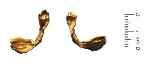
The chance that the Mamble find might represent a prehistoric deposit ought to be considered, but should be placed alongside the more concrete evidence for prehistoric precious metal finds from the Worcestershire-Shropshire-Herefordshire region. Although chance finds of worked flints from Bayton demonstrate activity in the area of late neolithic to early Bronze Age date, the area lies outside the classic distribution of elaborately furnished Bronze Age burials, and, although not unknown, Bronze Age gold objects are scarce in the region more broadly. This is also true of other classes of prehistoric gold finds like Iron Age torcs which, while represented by a growing number of local finds, are largely made of copper alloy, not gold, in the Worcestershire area, and are in turn generally found in the south of the county rather than the north.[iii] We might therefore doubt that the Mamble find was from a prehistoric deposit – whether a hoard, a burial or something else – but recognise that this is an unabashedly circular argument. The possibility remains, small though it may be.

Possibly, but not probably?  Bronze Age gold from Shrawley (PASID WAW-052196) Used on a CC-BY SA licence from © The Portable Antiquities Scheme/ The Trustees of the British Museum

Possibly, but not probably?
Bronze Age gold from Shrawley (PASID WAW-052196)
Used on a CC BY-SA licence from © The Portable Antiquities Scheme/ The Trustees of the British Museum

2) An ancient coin hoard?

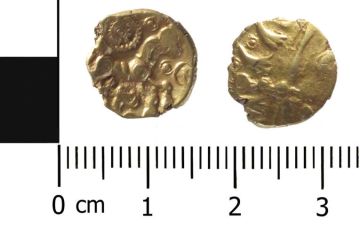
Another possibility is that the Mamble find was more specifically of gold coins. If so, analogy with modern finds might suggest that it was most likely formed of Iron Age – or maybe Roman – gold coins.[iv] Certainly we have ample evidence for the discovery of precious metal ancient coins in the late medieval and early modern periods – denarii of Trajan seem to have been included in the 1607 Higham on the Hill hoard (deposited c. 1195-1247) and woodcuts of British and Gaulish Iron Age coins were inserted into the 1600 edition of Camden’s Britannia, reminding us that incidental discoveries might occur even before the advent of modern deep ploughing.[v] Compared to the earlier prehistoric material there is a much more promising regional context in which to situate a possible late Iron Age or Roman gold coin hoard; Iron Age gold coins in particular are reasonably well represented in the Worcestershire-Shropshire-Herefordshire region, and the limited quantity of archaeological, metal detector and chance finds from Mamble and Bayton include Iron Age harness fittings, Roman coins and a possible Roman brick kiln – all of which points to more substantial settlement activity than for the earlier period – although allowances must be made for the much greater visibility of this material vis-a-vis earlier prehistoric archaeology.[vi]

A little more likely? Iron Age gold stater from Pershore (PASID WAW-C74642) Used on a CC-BY SA licence from © The Portable Antiquities Scheme/ The Trustees of the British Museum

A little more likely?
Iron Age AV quarter-stater from Pershore (PASID WAW-C74642)
Used on a CC BY-SA licence from © The Portable Antiquities Scheme/ The Trustees of the British Museum

3) An (?early) medieval hoard?

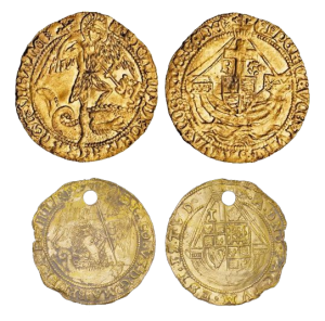
Along similar lines we might question whether the find was of later medieval gold coinage – or even recently deposited 16th/17th century gold coin. One traditional objection  – that gold coin rarely circulated in rural contexts, and therefore is unlikely to be found hoarded in the bleak hill country of the Worcestershire/Shropshire border –  appears quite untenable in light of reassessed finds and documentary evidence.[vii] Against this, however, we must plead the question of reception and familiarity; although the reforms of Henry VIII changed the shape of the English gold coinage considerably, the basic iconography of ships and angels so common to later medieval gold coins persisted in one form or another into the early 17th century; it’s hard to imagine that even the most stereotypical country bumpkin might not have recognised the find for what it once represented.

Top: AV angel of Richard III, 1483-5 (PASID LEIC-E209C1) Bottom: AV angel of James I, 1615-6 (PASID LEIC-C684F6).  Used on a CC-BY SA licence from © The Portable Antiquities Scheme/ The Trustees of the British Museum

Familiarity’s a funny thing…
Top: AV angel of Richard III, 1483-5 (PASID LEIC-E209C1)
Bottom: AV angel of James I, 1615-6 (PASID LEIC-C684F6).
Adapted on a CC BY-SA licence from © The Portable Antiquities Scheme/ The Trustees of the British Museum

Could we then raise the possibility of an earlier gold coin or object, whose iconography might be less familiar? We are, of course, in Staffordshire hoard country after all. Certainly possible, although again without any tantalising reference to gemstones or enamel work we’d do well to restrain ourselves. And again the testimony of existing artefact and coin distributions is less than encouraging; even accepting modern recovery biases the sparse evidence of gold coins of the 5th to 10th centuries tends much more towards southeast England, as indeed does the evidence for early medieval gold – or for that matter any – objects more generally.

These proposals clearly aren’t exhaustive, but to me seem a fairly reasonable précis of what the discovery made in the summer of 1681 might have been. So what results, if any, can be drawn from the speculation? The balance of probabilities leads me to think that what was found was likely an ancient – probably Iron Age, or maybe Roman – coin hoard (or single find?), but this has to contend with the fact that our sole reference makes zero reference to coins whatsoever. In any case, without any further documentary testimony – or, even better, a fortuitous survival lurking away from plain view – we’ll never really know for sure. But where’s the fun in that?


[i] John Field, A history of English field-names (Harlow: Longman, 1993), 218.

[ii] Coal mining in Mamble has been extensively considered in David Poyner & Robert Evans, “Mamble Colliery” Shropshire Caving and Mining Club Journal 4 (1997), 34. The 1838 Mamble tithe map records several fields names after coneys; WAAS S760-459.

[iii] With the notable exception of a possible fragment from Pershore: Derek Hurst and Ian Leins, “The Pershore hoards and votive deposition in the Iron Age” Proceedings of the Prehistoric Society 79 (2013), 304.

[iv] Roger Bland and Xavier Loriot, Roman and Early Byzantine gold coins found in Britain and Ireland (London: Royal Numismatic Society, 2010), 29.

[v] D.M. Metcalf, “Find-records of medieval coins from Gough’s Camden’s Britannia” Numismatic Chronicle 17 (1957), 193; Colin Haselgrove, Iron Age coinage in south-east England: the archaeological context (Oxford: British Archaeological Reports, 1987), 1.

[vi] Ian Leins, “Numismatic data reconsidered: coin distributions and interpretation in studies of late Iron Age Britain” (PhD diss., Newcastle University, 2012), 283.

[vii] (*cough*selfpromotion*cough*) Murray Andrews, “‘Noble, fair and fine’: Single finds of English gold coins from later medieval England and Wales” (forthcoming); see also the discussion in Christopher Dyer, A Country Merchant, 1495-1520: Trading and Farming at the End of the Middle Ages (Oxford: Oxford University Press, 2012), 122.


Scrambling about in the mud

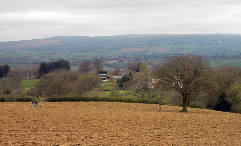
Readers will note that it’s been more than two months since I last updated this blog. There are some good reasons for that (honest!) – between jet-setting off to conferences in Basel and London and a rapidly-growing pile of coins to ID on my desk, I’ve had little time to put pen to paper – figuratively – on all themes medieval and Bayton-ian. Our friends in NWAG, however, have been far more productive, utilising the last few weeks to undertake a fieldwalking survey of a large area not far outside of the village. To my knowledge this is the first time that systematic fieldwalking has been conducted in the area; given that the number of known archaeological finds from Bayton can currently be counted on one hand, it’s very likely that the work will significantly increase our knowledge of the parish’s past. Should be good!

In any case, I hope to get back into the swing of things shortly. Until then, a picture will do:

A big field, full of stuff.

A big field, full of stuff.

Of Arsons and Parsons

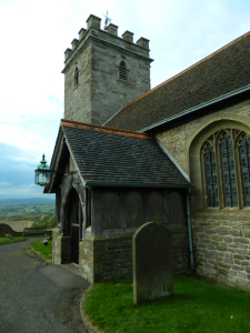
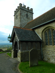
The south porch and west tower, St Bartholomew's.

St Bartholomew’s church, Bayton

Between May and July 1275 four royal justices and their entourage sat in residence at Worcester as they held a general Eyre for the county[1]. Over 46 days the commission heard more than 1000 civil and crown pleas brought before them, at least ten of which directly concerned disputes over land, administrative practices and criminality in Bayton parish. Most are fairly mundane; two berate villagers for not attending inquests into the (exceedingly clumsy) accidental deaths of Maud la Fole – who drowned in a marlpit – and Roger Edith – who fell on his own knife and died three days later[2]. Yet one case in particular stands out among the others. After a succession of hearings concerning larceny, trespass and theft, the justices heard a case concerning an arson attack on the parson’s grange in Bayton[3]. Since they dealt with arson and not homicide we can assume that nobody was hurt; perhaps the parson was not in residence that night, or had made it out of the blaze alive. The individuals who brought the case to the justices named a chief suspect, Thomas le Ku of Shakenhurst, a propertyless peasant who had fled the vill shortly after the attack. To the eyes of the justices his flight was proof enough, and its ruling was swift and straightforward; Thomas was exacted and outlawed.

The reference to this event is both concise and tantalisingly cryptic. If the Eyre’s notes and ruling are at all accurate, we are immediately presented with a question – what would drive Thomas to burn down the grange? The justices record no possible motive; perhaps in their eyes – and presumably those of the parson – Thomas was an individual malefactor, driven by the same sort of criminal instincts which allegedly led to theft and murder.  Certainly the judgment passed treated him as such. Yet the brief note may mask a more complex reality. In an interesting recent paper Müller draws attention to certain peculiarities about arson which distance it from other crimes in the medieval period. While burglary and extortion were offences which could considerably enrich their perpetrators, arsonists rarely benefitted financially from their acts[4]; while a thief like William Russell of Bayton could possess some 18d in chattels[5], Thomas the alleged arsonist possessed nothing. Furthermore, arson is a very visual and very social act, transmitting explicit messages to both the victim and the wider community, and it is therefore of little surprise that it features so prominently in acts of social rebellion or interpersonal disputes in medieval England. In 1348 a long-running series of disputes between Worcester Cathedral and the city’s lay community over legal privileges culminated in an organised attack on the cathedral priory; the monks were shot at with arrows and the priory set ablaze[6]. An almost identical incident had taken place some 21 years earlier in Bury St Edmunds, where rural peasants and townsfolk burned down several abbey houses and manors during a rising against the Abbot[7]. Numerous similar examples can be found throughout the period, most notably in the midst of the Peasant’s Revolt[8]. While other instances of arson might lack such overtly political functions – for example, a murder and arson committed by a group of ‘unknown malefactors’ at Holt might have been over a local dispute between the victim, Thomas Moliar, and one of the alleged perpetrators, Hamo le Messager[9] – it is clear that in many cases arson served as a ‘weapon of the weak’ in the face of exploitative relationships or unjust demands, providing a vivid and public statement that the victim had caused such problems to the perpetrator  that they felt justified to gain revenge through a dramatic destruction of property.

Might Thomas’ actions represent one such act of resistance? Certain aspects of the case might point in this direction. As the archetypal poor peasant Thomas fits the bill well –a man who possessed no chattels at the time of the Eyre, and who probably eked out some of a miserable living through the occasional sale of cooked meat. The local church held quite a different position. In 1291 Pope Nicholas IV’s taxatio valued St Bartholomew’s at £4, from a national standpoint hardly enormous yet locally of a significant economic weight. Its associates lived in some comfort; in the c.1280 Worcestershire lay subsidy a village clerk, William, is recorded as contributing 40d, an assessment placing him firmly within the top 25% of contributors – themselves a selection of the parish’s better off. That he possessed reasonable personal holdings is demonstrated in a dispute recorded in the Eyre between William and two villagers, Julian de Pres and Brian de Croft, over the unjust disseisin of 4 parts of a messuage and 3 acres of land with appurtenances he held in the vill[10]. While the wealth of the parson himself cannot be observed with such security, a hint of its scale is revealed in a record of the rights given to the vicar of Mamble when he assumed an additional post in Bayton shortly after August 1298; these included the vicarage house, a third share of the corn tithe, the whole of the ‘small tithes’ – renders from wool flocks, flax mills, orchards and gardens – and all the fees and offerings of the parishioners[11].  When the glebe is added to this mix it is clear beyond doubt that the parson occupied a very different rung on the class ladder to Thomas the alleged arsonist[12]. While the sparse details of the case make its interpretation inevitably speculative, given the extent of the church’s claims in Bayton it is certainly within the realms of possibility that the arson attack served as the culmination of some potentially long-running disputes over the rights of a wealthy clergy to exploit some of its poorest parishioners by tithing or otherwise; it is hard to see the action as anything other than a final resort by an aggrieved individual, and in this instance one taken by a man who – quite literally – had nothing to lose.

In any case, whether the law ever caught up with Thomas after the Eyre’s ruling is unknown. If they did, his fate was unlikely to be pleasant; a contemporary ruling on a case of theft in Bayton resulted in the hanging of the accused, and Bracton makes clear that no softer punishments would apply to arsonists[13]. While in the short term Thomas’ moves do not seem to have made much difference – parson Walter was still serving his post two years later[14] – memories of the affair may have been in the minds of Great Malvern’s priors when they took the first steps towards appropriating the church not long after the attack on 11 June 1275; the decision to make the vicar of Mamble also serve Bayton’s parish church might have reflected in part a desire to break with any lingering disputes between lay parishioners and the local clergy. If they were, the measures taken did little to alleviate the situation. In his 1781 Collections for the History of Worcestershire Nash preserves a detailed account of a 1344 exchange of livings between John Curdwall, vicar of Mamble and Bayton, and Thomas Aleyn, rector of St Clement’s, Worcester. Reporting to an inquisition held between several local rectors and vicars Curdwall explained his request ‘on account of the violent hatreds and quarrels that raged around Mamble, and that for fear of death, or some capital injury, which he might receive from his enemies, he could not safely live there’[15]. Apparently his peers agreed; Curdwall was presented to the rectory of St Clements on 18 July 1344.

Bibliography

Primary sources

Capes, W. ed. 1909. Registrum Ricardi de Swinfield, Episcopi Herefordensis, AD MCCLXXXIII-MCCCXVII. London: Canterbury and York Society.

Griffiths, R. ed. 1907. Registrum Thome de Cantilupo, Episcopi Herefordensis, AD MCCLXXV-MCCLXXXII. London: Canterbury and York Society.

HMSO. 1906. Calendar of Patent Rolls, Edward III Vol VIII, AD 1348-1350. London: HMSO

Röhrkasten, J. ed. 2008. The Worcester Eyre of 1275. Worcester: Worcestershire Historical Society.

Secondary sources

Baker, N., and Holt, R. 2004. Urban growth and the medieval church: Gloucester and Worcester. Aldershot: Ashgate

Bellamy, J. 1998. The criminal trial in later medieval England. Sutton: Stroud

Hilton, R. 1973. Bond men made free: medieval peasant movements and the English rising of 1381. London: Meuthen and Co.

Hilton, R. 1983. A medieval society: the West Midlands at the end of the thirteenth century. Cambridge: Cambridge University Press.

Müller, M. 2012. Arson, communities, and social conflict in later Medieval England. Viator. 43:2. pp 193-208.

Nash, TR. 1781. Collections for the history of Worcestershire. Vol 2. London: John Nichols.

Stroller. 1937. Worcestershire villages by ‘Stroller’. Vol 3. Worcester: Worcester Herald.


[1] Röhrkasten 2008, p viii

[2] Worc. Eyre. 1275, mem. 49 nos. 1210 and 1212.

[3] Worc. Eyre. 1275, mem 49a no 1249

[4] Müller 2012, p 195

[5] Worc. Eyre. 1275, mem 49a no 1245

[6] Baker and Holt 2004, p 299; Cal. Pat. Edw. III Vol. VIII, mem. 13d

[7] Müller 2012, p 203

[8] Hilton 1973

[9] Worc. Eyre. 1275, mem 36d no 787

[10] Worc. Eyre. 1275, mem 12 no 175

[11] Reg. Ric. Swin, fol 121; Stroller 1937, p 29

[12] Hilton 1983, p 63

[13] Worc. Eyre 1275, mem. 49a no 1245; Bellamy 1998, p 187

[14]  Reg. Thom. Cant., fol. 41b

[15] Nash 1781, p 159

Floods, storms and environmental nasties in medieval Worcestershire

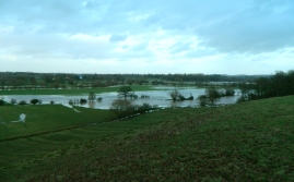
Floodwaters over the Powick Hams, 6 Jan 2013

Floodwaters over the Powick Hams, 6 Jan 2014

It’s hard to escape the news – and physical reality – of the floods and storms currently drenching Britain, which, according to the Met Office, are the worst in some twenty years and aren’t being helped by climate change and swingeing cuts to flood defences. That said, so far we’ve got off relatively lightly in Worcestershire, road closures and drenched fields notwithstanding. This makes a mild and welcome change from the norm in a county whose topography and drainage – bearing more than 1700km of streams and rivers amidst large lowland floodplains – have historically made it ripe for both farming and flooding.

Given this objective situation, it’s unsurprising to see the impact of floods, storms and other environmental events on everyday life in Worcestershire inscribed in the medieval documentary and archaeological records. The river Severn, at the centre of the county’s waterways, provides particularly abundant clues, and one of its earliest recorded floodings on 4 June 1258 is vividly described in the Flores Historiarum. Triggered by ‘a terrible storm of wind, accompanied by torrents of rain’[1], the Severn broke its banks from Shrewsbury to Bristol, flooding all the meadows and cornfields along its route and destroying all the crops. These were not the only victims; ‘some men were even drowned in the violent waters, and innumerable boys, and great quantities of animals of every sort’. The deluge was of a scale unseen in living memory, and to the eyes of locals had only one origin – ‘the secretest gulfs of hell’. Further floods are recorded, albeit on a much smaller scale; in 1374 flooding of the Severn caused severe damage to the bridge at Evesham[2], and recurrent floods at the vill of Strensham resulted in a 1395 indult allowing residents to bury their dead at the nearby chapel rather than the parish church of Pershore Abbey[3]. In some cases even these could have severe results, with repeated flooding in the late 14th century leading to the eventual abandonment of the mill complex at Bordesley Abbey[4]. Sometimes, however, it had its upsides; in 1325 it meant that the ruined mill at Naunton Beauchamp could finally grind cereals once again[5].

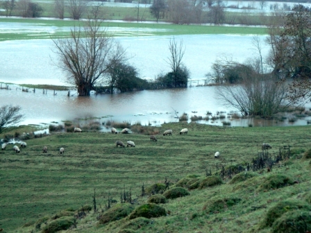
For such a perennial problem it’s equally unsurprising that people should find ways to overcome nature’s difficulties – or at least to work around them. If the raised floor levels of the transept at Bordesley Abbey constitute a low level damage mitigation policy[6], the earthwork defences erected parallel to the Severn at Bushley are of a quite different scale, with linear banks and draining ditches stretching out in sections over roughly 1115m[7]. However, in a time when flooding could be attributed to devilry, perhaps the best alternative approach to risk-mitigation was spiritual; amidst heavy rains in 1437 the Prior of Worcester ordered a procession of the shrine of St Oswald across the city, just as ‘hyt hath byn afore this time for cessying of such continual reyne’[8]. At least in agricultural terms, however, perhaps a more straightforward approach was to avoid cultivating the most risky floodplains altogether. The photo below of today’s flooding along the Powick Hams might reveal this strategy in action; ridge and furrow earthworks extend down the slope of the hill in the foreground, terminating along a boundary beyond which the land is a lot more sodden – and lacking the obvious marks of cultivation.

Sheep grazing amidst extant ridge and furrow along the Powick Hams, 6 Jan 2014

Sheep grazing amidst extant ridge and furrow along the Powick Hams, 6 Jan 2014

Where does Bayton fit into all this? Although the medieval vill is sited some 400-600 ft above sea level, the presence of the river Rea and several tributaries – principally the Shakenhurst, Tanner’s and Mill Brooks – in its immediate vicinity do pose occasional flood risks, proven in practice in June 2012 when lower lying areas of the parish were left flooded after facing as much as 63.2mm of rain in a single day[9]. As these were the locations where mills – such as that recorded at Shakenhurst in 1275 – were sited, it is easy to imagine the risk posed by flash-flooding along the Rea to the local economy, disrupting food production and causing grave consequences in the incomes of millers and mill owners. How residents dealt with these challenges is as yet uncertain, although we can easily imagine that, like elsewhere in the county, both practical and spiritual works had a role to play.

Bibliography

Astill, G. 1993. A medieval industrial complex and its landscape: the metalworking watermills and workshops of Bordesley Abbey. York: Council for British Archaeology.

Averill, M. 2012. More record floods in 2012. Wyre Forest Study Group Review 2012. pp 26-27.

Lloyd, D. 1993. A history of Worcestershire. Chichester: Phillimore.

Page, W., and Willis-Bund, J.W. 1924a. Parishes: Naunton Beauchamp. In W Page and JW Willis-Bund, eds. A history of the county of Worcester. Vol 4. London: Victoria County History. pp 143-7.

Page, W., and Willis-Bund, J.W. 1924b. Parishes: Strensham. In W Page and JW Willis-Bund, eds. A history of the county of Worcester. Vol 4. London: Victoria County History. pp 202-8.

Rahtz, P., and Hirst, S. 1976. Bordesley Abbey, Redditch, Hereford-Worcestershire. First report on excavations, 1969-72. Oxford: BAR

Rudge, E. 1820. A short account of the history and antiquities of Evesham. Evesham: J Agg.

Yonge, C. 1853. The flowers of history, especially such as relate to the affairs of Britain. Vol. II. A.D. 1066 to A.D. 1307. London: Henry G Bohn


[1] Flor. Hist., p 357

[2] Rudge 1820, p 108

[3] Page and Willis-Bund 1924b

[4] Astill 1993, p 54

[5] Page and Willis-Bund 1924a

[6] Rahtz and Hirst 1976, p 71

[7] WSM46806

[8] Lloyd 1993, p 45

[9] Averill 2012, p 26

Counting people: demographic change in medieval Bayton

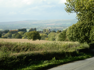
Looking west towards Bayton village.

Looking west towards Bayton village.

Once home to a small but significant manorial community, the disappearance of the vill of Carton in northeast Bayton serves as a potent reminder of the waves of demographic change experienced in the parish over the last millennium. Charting population changes provides an essential background to the parish’s medieval history, but is inevitably hampered by the lack of anything approaching modern census records; in the case of Bayton, we also lack the manorial court rolls which have proven so informative for demographic studies elsewhere in the West Midlands[1]. In reconstructing Bayton’s medieval population we are therefore heavily reliant on the evidence of taxation records written up at a number of fixed and unevenly-distributed dates throughout the 11th-16th centuries, none of which were ever meant to say much about population in the first place. Problematic as these sources are, they do let us make some population estimates at a series of fixed points, illuminating at least the broad contours of demographic change in the medieval parish.

Point 1: Domesday Book

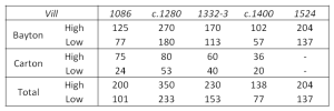
The earliest of these fixed points is the 1086 Domesday survey, whose usefulness as a demographic ‘benchmark’ is well-established albeit much debated in the details[2]. In one of the more useful methodological surveys of English historical demography Goose and Hinde propose a series of multipliers to convert Domesday’s household listings into viable population estimates[3], using which the parish entries –divided in the survey between the manors of Bayton and Carton – can be transformed into estimates of 77-125 people at Bayton and 24-75 at Carton. These estimates clearly vary quite considerably in the details, but serve as eminently reasonable approximations of the highs and lows of where population is likely to have lain, suggesting a parish-wide total of some 101-200 people in the later 11th century.

Point 2: c.1280 lay subsidy

Our next ‘fixed point’ for demographic estimates in the parish comes almost 200 years later in the form of another tax document – the c.1280 Worcestershire lay subsidy. The subsidy, levied at an uncertain rate[4], lists the names of some 27 taxpayers in Bayton and 8 in Carton whose contributions varied between 1s – 10s apiece. It is not unreasonable to assume that the taxpayers represent heads of households, although given the financial scale of their payments it would be unreasonable to assume that they represent all households; more likely many were exempted by poverty, while a few more might have conveniently disappeared when the tax assessors came to visit[5]. Following Dyer[6], the high estimate used here for the c.1280 lay subsidy assumes that those listed represent only 50% of households in their respective vills  – the remaining 50% exempt from or evading the survey – and that each household on average contained 5 people, producing high estimates of 270 people in Bayton and 80 in Carton. These figures are clearly quite optimistic, and can be complemented by lower estimates which assume that only 40% of households went untaxed and on average contained 4 people, suggesting totals of 180 residents in Bayton and 53 in Carton. In both the individual vills and the whole parish we can therefore identify a steady rate of population growth during the 200 years since the Domesday survey, mirroring broader trends at the national level[7].

Point 3: 1332/3 lay subsidy

Using the same principles we can make some population estimates from the 1332/3 lay subsidy. Levied at a fifteenth in rural areas like Bayton, the subsidy records 17 taxed individuals at Bayton and 6 at Carton, which using the same assumptions about evasion and household sizes adopted for the previous subsidy gives estimates of 113-170 at Bayton and 40-60 at Carton. This suggests a significant decline in settlement size over some c.50 years in the early 14th century – hardly surprising given the massive famines and livestock murrains sweeping Europe at the time.

An interlude – what about the plague?

By this point we have some reasonable estimates for Bayton’s population on the eve of the massive demographic crises of the mid-late 14th century. Assessing the impact of these crises at the local level usually involves comparing pre-plague figures with post-plague figures, the latter of which are commonly calculated from the 1377-81 poll taxes[8]. Here the record for Bayton hits a brick wall, as very few Worcestershire poll tax records have survived – none of which include the parish[9] – and alternative sources like manorial court rolls are absent or inconclusive. What does this mean for demographic history in this critical period?

As in most places in England, it’s hard to imagine that Bayton’s inhabitants escaped the plague years unscathed. On 21 July 1349 the parish received a new vicar, William de Emynghope, on the death of his predecessor, Thomas Aleyn[10] – a fate shared with almost half of Worcestershire’s parish clergy between July and December 1349, and one that whiffs quite strongly of the plague[11]. This alone, however, is not sufficient to establish local mortality rates, much less their overall impact on the local demographic pattern. Analogy – problematic as it is – seems to be the only source for estimating parish population at the end of the 14th century. This presents new problems, as studies which have assessed pre- and post-plague demographic change underline some quite substantial differences at the national and local levels; the most commonly cited national figure suggests that the English population approximately halved in size between c.1340-1400, although varying between counties, parishes and manors. Worcestershire certainly seems to have been one of the worse-hit counties in England, its maximum percentage mortality reaching 45-50% in 1349 alone[12].

Bearing this in mind, it seems fair to propose some very tenuous population estimates for Bayton and Carton c.1400, using the 1332/3 lay subsidy estimates as a benchmark. A low population estimate c.1400 assumes that the lower population estimate for 1332/3 was hit particularly hard in the mid-14th century, halving in size over c.50 years to around 57 individuals in Bayton and 20 in Carton. A more optimistic estimate assumes that the higher population estimate for 1332/3 got off slightly lighter, contracting by 40% by c.1400 to approximately 102 people in Bayton and 36 in Carton. The conditionality of these estimates cannot be stressed enough – after all, they are assumptions of what may have happened based on analogies from elsewhere in the country – but serve to provide a useful indication of the likely practical impact of demographic crisis on a small parish community in the mid-late 14th centuries.

Point 4: 1524 lay subsidy

The exchequer lay subsidy of 1524 provides a welcome opportunity to move towards some firmer ground for population estimates, but presents a new set of problems. Unlike previous incarnations Bayton and Carton were not taxed separately in the 1524 subsidy, instead being assessed together as a parish. The change coincides with the declining importance of Carton, whose manor was valued at only 26s 8d per year by 1400 – an absurdly low sum little more than its residents had contributed in tax alone c.120 years earlier[13]. The 1524 entry for Bayton parish lists 30 people contributing to the tax, although as ever it is unclear whether these are heads of households or taxable males aged 16 and over[14]. The high and low estimates given here have been calculated using the method outlined by Goose and Hinde[15], and imply a parish-wide population of 137-204 people.

Looking at the long term

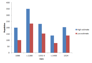
The results of this survey have given us four reasonable population estimates at fixed dates – 1086, c.1280, 1332-3 and 1524 – and an additional (albeit more problematic) estimate c.1400. The scope of the estimates are limited – having an obviously uneven chronological distribution and telling us very little about sex ratios, birth rates and death rates – but do illustrate some of the broad contours of Bayton’s population history, largely mirroring the national pattern of steady growth in the 11th-13th centuries, a rapid decline by the 15th century and a slow resumption in growth by the early 16th century[16]. In absolute terms, the estimates for c.1280 reveal a parish population that had reached a peak never again experienced until the late 18th century.

Population estimates for the vills of Bayton and Carton, plus total parish population, at fixed dates.

Population estimates for the vills of Bayton and Carton, plus total parish population, at fixed dates.

Looking at the estimates in a general way it is interesting to note the differences in scale between the vills of Bayton and Carton, the latter consistently sustaining a far smaller population yet retaining enough significance to be taxed independently before the 16th century. This picture is consistent with a 1307 description of Carton as a hamlet[17], and raises questions about Habington’s description of it as ‘a place of great accompte in thys paryshe’ – which presumably alludes more to the prestige with which he held  its noble landholders than its medieval size or value. In hindsight the declining population at Carton seems to foreshadow its eventual desertion as much as its declining tax payments do[18]; the human impact of a sizeable fall in population in so small a vill would no doubt be felt more sorely than in its larger counterpart,  perhaps therefore providing an interesting counter-example to Dyer’s suggestion that woodland communities were hit less critically than those in champion landscapes by a declining population[19].

The changing shape of Bayton's parish population, 1086-1524.

The changing shape of Bayton’s parish population, 1086-1524.


[1] Razi 1980; Dyer 2012

[2] Goose and Hinde 2006

[3] Goose and Hinde 2007

[4] Lay Subs. R. Worcs. c. 1280, p v. Amphlett later suggested that the tax was levied at a tenth, although it is unclear where he derived this figure from; see Lay Subs. R. Worcs. 1332-3, p vi

[5] Were it not for fleeing the parish after burning down the grange some 5 years earlier, presumably Thomas le Ku of Shakenhurst would have been one of those exempted from the subsidy through personal poverty – possessing no chattels at the time of his blacklisting. Worc. Eyre 1275, mem. 49a no. 1249

[6] Dyer 2012, p 133

[7] Hatcher and Bailey 2001, p 29

[8] Goose and Hinde 2007, p 78

[9] Fenwick 2005, p 126

[10] Reg. Joh. Trill. At this period Mamble and Bayton shared clergy, despite retaining separate parish churches.

[11] Lloyd 1993, p 45

[12] Hinde 2003, p 43

[13] Cal. Inq PM. Vol. XVIII., no. 62; Lay Subs. R. Worcs. c. 1280, p 59.

[14] Faraday 2003

[15] Goose and Hinde 2007, p 79

[16] Hatcher and Bailey, p 29

[17] Cal. Inq. Vol. V Edw. II., no 57

[18] Lay Subs. R. Worcs. c. 1332-3, p 24; Lay Subs. R. Worcs. c. 1280, p 59

[19] Dyer 2012, p 134

Bibliography

Primary Sources

Amphlett, J., ed. 1893. Lay subsidy roll for the county of Worcester, circ. 1280. Worcester: Worcestershire Historical Society

Amphlett, J., ed. 1899. Lay subsidy roll, AD 1332-3, and Nonarum Inquisitiones, 1340, for the county of Worcester. Worcester: Worcestershire Historical Society

Faraday, M., ed. 2003. Worcestershire taxes in the 1520s: The military survey and forced loans of 1522-3 and the lay subsidy of 1524-7. Worcester: Worcestershire Historical Society

Fenwick, C., ed. 2005. The poll taxes of 1377, 1379, and 1381, Part 3: Wiltshire-Yorkshire. Oxford: Oxford University Press.

HMSO. 1908. Calendar of inquisitions post mortem and other analogous documents preserved in the Public Record Office, Vol V Edward II. London: HMSO

Kirby, J., ed. 1987. Calendar of inquisitions post mortem, Vol XVIII 1 – 6 Henry IV (1399 – 1405). London: HMSO

Parry, J., ed. 1912. Registrum Johannis de Trillek, Episcopi Herefordensis, AD 1344-1361. 2 vols. Hereford: Wilson and Phillips

Röhrkasten, J., ed. 2008. The Worcester Eyre of 1275. Worcester: Worcestershire Historical Society.

Secondary Sources

Dyer, C. 2012. A country merchant, 1495-1520: trading and farming at the end of the Middle Ages. Oxford: Oxford University Press.

Goose, N., and Hinde, A. 2006. Estimating local population sizes at fixed points in time: Part I – general principles. Local Population Studies. 77. pp 66-74.

Goose, N., and Hinde, A. 2007. Estimating local population sizes at fixed points in time: Part II – specific sources. Local Population Studies. 78. pp 74-88.

Hatcher, J., and Bailey, M. 2001. Modelling the Middle Ages. Oxford: Oxford University Press

Hinde, A. 2003. England’s population: a history since the Domesday Survey. London: Hodder.

Lloyd, D. 1993. A history of Worcestershire. Chichester: Phillimore.

Razi, Z. 1980. Life, marriage and death in a medieval parish : economy, society and demography in Halesowen, 1270-1400. Cambridge: Cambridge University Press

Something slightly different

Leigh, Worcestershire. Contains Ordnance Survey data © Crown copyright and database right 2013

Leigh, Worcestershire. Contains Ordnance Survey data © Crown copyright and database right 2013

Armed with little more than a couple of maps, two pairs of socks and a good(-ish) set of walking boots, last Sunday I made a temporary departure from the usual schedule of Bayton-based medievalism to set off on an 8-mile round trip to the village of Leigh near Malvern. There were two main reasons for the journey:

  1. Leigh has several extant medieval sites – some of which are of national significance – which can be associated with its holding by Pershore Abbey.
  2. For early November, the weather was remarkably nice.

Having sufficiently justified it to myself, I set off in the early afternoon on a walk across a lot of muddy fields, a few paved roads and an active train track. Surviving potential flattening I arrived around an hour later at Leigh’s parish church, an imposing sandstone structure dating mostly to the 12th-14th centuries. The church has the peculiar characteristic of retaining its pre-conquest devotion to St Edburga, the product of a close association between its landholder, Pershore Abbey, and Edburga’s cult; shortly after her canonisation in 972 the abbey acquired a number of her relics, stimulating a cult whose accoutrements included a dedicated chapel at Pershore and a 1226 grant to host a fair on her feast day, 15 June.

St Edburga's church, Leigh

St Edburga’s church, Leigh

The church has several extremely interesting exterior features, including an elaborate 14th century ashlar tower and a potentially 15th century timber porch, although its interior is particularly significant for containing a remarkable 12th century relief carving of Christ. However, at the time I visited the lights weren’t on – and I couldn’t find a light switch – so all my photographs look particularly bad; thankfully, a photograph taken for the Corpus of Romanesque Sculpture is more than enough to whet the appetite.

One of the more visible internal features, however, was a plaque hanging in the nave listing the rectors of the church and their dates of appointment. The document has evidently been carefully compiled from several sources by earlier parish historians – one of whom, Lisle-Wright, has produced a handy short history of the church.  While the record has inevitable limitations – there are no records of rectors predating 1274, for example, leaving more than a century of the church’s life without local documentation – it nevertheless sheds interesting light on ecclesiastical arrangements in medieval Leigh. Between 1274 and 1556 it records some 38 rectors, representing an average post-holding of 7.5 years; for each quarter-century between 1275 and 1474 there are generally two to four rectors recorded, demonstrating a high degree of fluidity in the holding of ecclesiastical posts. In other words, the rectors of St Edburga’s do not seem to have stayed in their job all that long. The real significance of the changes can be seen most clearly for 1432 and 1504, when the post swapped hands twice in one year. By the early 16th century there is an enormous growth in the number of named rectors.

Number of newly-appointed rectors by quarter-century at St Edburga's, Leigh.

Number of newly-appointed rectors by quarter-century at St Edburga’s, Leigh.

The records provide a strong indication of sudden and localised demographic change, the most likely cause of which would be disease. The most obvious of these is plague, a fate that is likely to have befallen Rector Willelmus de Burthone, who in the ominous year of 1349 was replaced by a new postholder, Walterus de Morton.

After leaving the church I did think to take a visit to the Leigh Court tithe barn, conveniently located right next door. This building, managed by English Heritage, is one of the oldest extant cruck-built barns in England, dated to c.1325 using stylistic features and dendrochronology. The barn would have served as a centre for the storing and threshing of grain cultivated on the monastic granges, and testifies to the scale – both physical and financial – of Pershore Abbey’s agricultural interests during the later Medieval period. Unfortunately however I made an error of timing; the barn is now closed for winter. In any case, at least I got a good view of the exterior; the photo really doesn’t do it any justice.

Leigh Court Tithe Barn

Leigh Court Tithe Barn

At this point it was beginning to get darker, so I made the executive decision to head back, albeit via the footpath past Leigh Castle Green, a small Norman motte that seems to have miraculously escaped later plough damage – although the number of animal burrows surrounding the site suggest that below ground things might not be quite as nice as they seem. While no archaeological research has been conducted that might shed light on the site, a documentary tradition exists relating the motte to the manor of Castleleigh, held by the Pembridge family in the 13th century; nevertheless, as at Leigh church, the documentary record here seems to postdate the physical evidence by at least a century, leaving many questions essentially open. At this point, sunshine rapidly receding, I decided to hop back on the homeward path.

The motte at Leigh Castle Green. Note the large spoil heap at the bottom right, caused by animal burrowing; these surround the site from most directions.

The motte at Leigh Castle Green. Note the large spoil heap at the bottom right, caused by animal burrowing; these surround the site from most directions.

The visit to Leigh is useful in providing some stark contrasts with Bayton. The size and scale of the tithe barn is ample evidence that the Abbots of Pershore had a very profitable holding at Leigh; St Edburga’s lavish 14th century tower speaks volumes about the amount of surplus income in their possession, readily available for new expenditure. The entry for St Edburga’s in Pope Nicholas IV’s 1291/2 taxatio reiterates this key point, listing the church in two portions; that held by Pershore Abbey was valued at £8 6s 8d, rising to £13 6s 8d when both portions are combined.

The 1332/3 lay subsidy entry for Leigh, however, demonstrates that wealth was not only possessed by the church, with a total of £4 5s 10d levied. This conclusion is supported by numismatic evidence, with 40 coin finds recorded by the PAS and EMC in the parish; assuming these represent casual losses, they demonstrate a sizeable amount of circulating monetary wealth – from groats to farthings – with a chronological distribution often paralleling the county average, albeit with proportionately fewer pre-Short Cross and more post-1465 issues.

Coin loss profile for Leigh. Periods are those of Kelleher 2012; Worcester regional mean from Andrews 2013

Coin loss profile for Leigh. Periods are those of Kelleher 2012; Worcestershire mean from Andrews 2013

By contrast a noticably poorer community is evidenced at Bayton, whose parish church, St Bartholomews, was valued at only £4 in the taxatio, and whose 1332/3 lay subsidy levies totalled only £2 3s 6d – by no means a small sum, but nonetheless considerably smaller than Leigh’s contribution. The numismatic evidence for Bayton’s wealth is considerably weaker, as very few coin finds have been discovered or reported, although a single Short Cross halfpenny recorded by the PAS underlines the fact that money did indeed circulate in the parish. In any case, the wealth disparity between Bayton and Leigh seems to have had deep roots. In a previous post we have seen that Bayton’s 1086 valuation was £4; the valuation for the two holdings at Leigh were a remarkable £18 10s.

As such, Leigh serves as a good example of a wealthy medieval holding in Worcestershire; Bayton, by contrast, reveals a noticeably poorer counterpart, emphasising the diversity of even a comparatively small county like Worcestershire during the Middle Ages. As local historians this should warn us away from making sweeping generalisations about ‘medieval life’ – within less than 20 miles people could experience very different standards of living, as true in the past as it is today.

‘A plain structure…improved of late’

The south porch and west tower, St Bartholomew's.

The south porch and west tower, St Bartholomew’s.

…or at least that is how John Noake described Bayton’s parish church, St Bartholomew’s, in his 1868 Guide to Worcestershire. The improvement Noake describes is presumably the church tower, built some time c.1817-19; little less than 100 years later the church underwent a further round of ‘improvements’, when much of the building was remodelled in the decorated style at the hands of noted architects John Oldrid Scott & Son. Yet beneath centuries of such renovation and repair lies the skeleton of a Medieval parish church, first constructed in the 12th century and long at the beating heart of local life.

Yesterday I had the pleasure of making my first visit (pilgrimage?) to St Bartholomew’s, following a brisk morning of bramble clearing at Timberlake with NWAG. While this post isn’t the place for a detailed study of the church – which will have to wait until some other (distant) time – there are nevertheless three features I want to point out, as they frame the Medieval history of Bayton rather nicely.

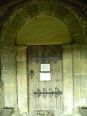
South door exterior, St Bartholomew's.

South door exterior, St Bartholomew’s.

The first key feature is the exterior of the south door to the nave, now pleasantly tucked behind the 1905 porch. The doorway is a classic example of 12th century architecture, featuring chamfered imposts, a rounded arch decorated with lozenge and chevron motifs and a plain – and heavily eroded – tympanum. According to Pevsner, during the 19th century Noake observed a figured tympanum at the church, with similarities to those at Rock and Chaddesley Corbett; however, as the picture shows, this decoration very clearly no longer exists.

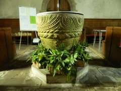
Roughly contemporary to the south door is the second feature I want to highlight, a hefty-looking Norman drum font located at the west end of the nave. Partially damaged by the previous addition of  a locking lid, the font is decorated with two sections of sculpture divided in the middle by a thick plait; the Corpus of Romanesque Sculpture, which studied the font in the early 1990s, notes some decorative similarities with those at Rock (Worcs.) and Linley (Salop.). The first comparison is particularly interesting, as it has also been observed for the exterior door; it seems likely that both were works of the 12th century ‘Herefordshire School’ of sculptors.

The font, St Bartholomew's.

The font, St Bartholomew’s.

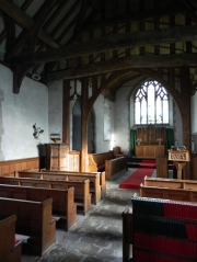
Looking east towards chancel, St Bartholomew's.

Looking east towards chancel, St Bartholomew’s.

Third and finally, something a little bit more recent – the nave roof, collars and cambered tie-beams, most of which are thought to be of c.15th century date. In general I always find it amazing to see surviving timber structures, and certainly it is quite an achievement that these have survived not only natural and not-so-natural damage, but also several rounds of increasingly vigorous ‘improvement’. In any case they provide a valuable indication of the appearance of the church in the later Middle Ages – and a pretty one to boot.

Bayton in the Domesday Book

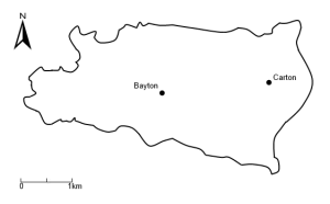
As the first proper post on this blog it seems appropriate to begin with that erstwhile starting point of local histories – Domesday Book. The modern parish of Bayton, perched on the Worcestershire side of the hundredal boundary between Stottesdon (Salop.) and Doddingtree (Worcs.), contains two manors recorded in the 1086 Domesday survey – Bayton to the west of the parish and Carton to the east (Fig 1). The relevant entries can be consulted via the Open Domesday here and here – or, for readers who prefer a hard copy, as entries 15,6 and 19,10 in the Phillimore Domesday. The Domesday entries for Bayton offer a detailed glimpse into life during the transition from the late Anglo-Saxon to the Norman periods, and, for our purposes, provide a crucial starting point for the study of the parish in the Middle Ages.

Domesday Manors in Bayton parish. Contains Ordnance Survey data © Crown Copyright and database right 2013

Fig 1: Domesday Manors in Bayton parish. Contains Ordnance Survey data © Crown Copyright and database right 2013

Out with the old, in with the new – Lordship in Norman Bayton

The impact of the Norman Conquest is reflected in the Domesday Book by the changing names of pre- and post-conquest landholders. Prior to 1066 the majority of landlords in England had been English, a situation almost wholly reversed by 1086 when only 8% of landowners had English names  – the result of what Dyer aptly describes as ‘the largest transfer of property ever seen in English history[1]. This ‘classic’ Domesday pattern of shifting landlords is clearly visible at the manor of Bayton. Formerly two pre-conquest manors held by Edric and Leofwin, the merged 1086 Bayton manor was held by Ralph de Tosny, a significant Norman landowner with 110 post-conquest holdings across the country. Almost 40% of de Tosny’s Domesday estates were located in Herefordshire and Worcestershire, and almost 11% in the Doddingtree hundred, in which he was the largest single landholder – evidently a powerbase of considerable local importance.

While the manor at Bayton followed the classic transition from English to Norman hands, that at Carton did not – albeit for quite unusual reasons. Before the conquest the manor at Carton had been a holding of Richard Scrope, a Norman who was granted land in Herefordshire by Edward the Confessor and by 1066 had amassed some 8 manors in a band across Herefordshire, Shropshire and Worcestershire; his holding at Richard’s Castle (Herefs.) contains one of the few likely pre-conquest castles in England and Wales[2]. This pre-conquest Norman manor by definition could not have been transferred from English hands in the aftermath of the conquest, and instead descended to Scrope’s son, Osbern, himself a Norman landowner of some significance; before 1066 he held 24 manors, expanding to 111 in 1086.

In any case, the demonstrable absence of post-conquest English lords at Bayton and Carton seems to have extended to lesser landholders too. Both estates were held by sub-tenants – at Bayton, Rainer, and at Carton, Odo. While little is known of these individuals their names are tellingly derived from Old Germanic rather than Old English, suggesting that both were most likely Normans – or at least Frenchmen[3] – themselves.

Populating Norman Bayton: Demographics and social structure

So much for the lords – what about the peasants? The entries for Bayton and Carton record some 20 and 12 households respectively, settlements of medium to small size by national standards. What is true nationally is here also true in local terms; when the 40 Doddingtree estates are ranked by numbers of households, the Bayton estate comes in 14th place and Carton in 25th.

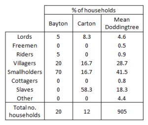
The composition of these households sheds considerable light onto the complex social structures existing in Norman England. Four non-lordly household groups are present at both manors – villagers, smallholders, slaves and riders; conversely, other contemporary groups found in Doddingtree hundred – the freeholders, cottagers and certain specialists – are absent[4].

The household composition of Domesday estates in Bayton, Carton and Doddingtree hundred

Fig 2: The household composition of Domesday estates in Bayton, Carton and Doddingtree hundred

The relative proportions of household types in Bayton and Carton differ noticeably from the notional average for Doddingtree manors, presumably reflecting basic differences in the organisation of estates; that at Carton was evidently dependent on slave labour, while that at Bayton reliant on smallholders (Fig 2).

If certain assumptions are made about the compositions of Domesday households it is possible to turn these figures into population estimates. The most straightforward method is to apply a simple multiplier to household numbers, although this relies on several unspoken assumptions about the definitions of households, their average sizes, and omissions from the survey. A more sophisticated method proposed by Goose and Hinde[5] takes into account these factors and proposes both low and high estimates; using this approach, we can estimate populations of between 77-125 at Bayton and 24-75 at Carton. Evidently these estimates fluctuate quite substantially, but provide a useful approximation of the likely limits between which real population sizes probably fell.

Agriculture and economy in Norman Bayton

Behind these communities lay a relatively sophisticated agricultural economy, on which Domesday sheds much light.

Sustaining the living standards of the lord and his household was the demesne land, the scale of which can be inferred from the number of ploughs in the lord’s possession. At Bayton some three ploughs were in demesne, while at Carton two ploughs were in demense; pulled by teams of eight oxen apiece, such ploughs were each capable of cultivating up to 100 acres per year, giving a potential yearly demesne acreage of 300 acres in Bayton and 200 acres in Carton[6]. The absolute extent of manorial demense might in fact be larger – or indeed, smaller – than these figures suggest, as there is no indication in the relevant entries as to whether there were additional holdings held in fallow each year, or whether tenant ploughs were also employed to work the lord’s fields[7]. If these ploughs were used to maximum capacity, some 24 oxen would be required to farm the demense at Bayton and 16 for that of Carton. Each plough would need to be manned by two people; at Carton this task would have been conducted by slaves, while at Bayton it would presumably have been one of the obligations of the villagers and smallholders.

Records of tenant ploughs can similarly be used to infer the nature and scale of peasant holdings. The 18 peasant households of Bayton held some 12 tenant ploughs, the potential equivalent of 1200 acres of farmland – as much as four times the size of the lord’s demesne. These ploughs required some 96 oxen to pull them; each peasant household might have held 4-5 oxen, joining together when needed to form complete ploughteams. Evidently the two-person teams required to use the ploughs most efficiently could not have been formed if only operated by (presumably male) heads of households, suggesting that women or younger family members played a crucial role in peasant farming. At Carton the four peasant households shared 1 ½ ploughs, the equivalent of 150 acres of farmland; however, Domesday notes that three extra ploughs were possible, potentially suggesting that peasant fields were not exploited to their full potential. Quite what crops were sown on the fields is unclear, although wheat, rye, corn and oats are likely candidates.

Crops needed to be ground into flour, buildings and equipment built and repaired and spiritual needs fulfilled; the evidence for these services – or the lack thereof – can be found in the manorial appurtenances listed in the Domesday entries.  The manor at Bayton possessed a mill, valued at 5s, which would have processed flour for both lord and peasant – albeit for a fee. The site of this mill is unknown, but would presumably have been along one of the tributaries of the River Rea. The manor at Carton included woodland, 0.5 leagues long and 3 furlongs wide, which might have supplied timber for building and grazing land for pigs. Curiously, no woodland is recorded at Bayton, despite abundant toponymic evidence for woodland in the parish[8]; this might suggest that the Domesday manor did not extend as far north or south as the modern parish, but alternatively this woodland might simply have been omitted from the survey records. The services of smiths and priests would have been required to cater for the practical and spiritual needs of the population – neither are recorded at Bayton or Carton, but services may have been enlisted from the smiths and priests of neighbouring Sodington and Alton.

The records of Domesday therefore suggest two small-to-medium sized manors at Bayton and Carton, organised around mostly self-sufficient agriculture but also enmeshed in a wider local economy. This is also suggested by the tax assessments levied on the manors, which for Bayton were levied on 3.5 hides – a medium-sized sum – and 1.25–1.3 hides at Carton – a small sum.

The manorial valuations tell a similar story, totalling £4 for Bayton and 5s for Carton; these are presumably the annual payments rendered to the lord of the manor, although whether they represent peasant rents, total manorial income or net manorial output is unclear. Both manors list at least two values – one value pre-1066, another in 1086, and, in the case of Bayton, another c.1070 – revealing that the differences in manorial size and wealth had been well established by the time of the Domesday survey. They also demonstrate that quite substantial changes in value had taken place in both estates during the post-conquest period. At Bayton the estate value had halved by c.1070, yet expanded to 133.3% of its pre-conquest value by 1086; the manor at Carton was worth only half its pre-conquest value in 1086.

The causes of these changed values are uncertain. The traditional argument that declining values should be associated with the destruction of English estates by Norman knights is unconvincing; Carton, a demonstrably pre-conquest Norman manor, had undergone a marked contraction in value by the time of the Domesday survey, while the early contraction at Bayton had been totally reversed in the same period, as it had been in the neighbouring pre-conquest English manors of Alton and Mamble. Presumably such changes in value were a product of the interplay of several factors – including among others changes in soil conditions, population, the extent of farmed ploughland and structural changes in manorial organisation. Bayton might offer an example of the latter, being the product of two merged pre-conquest manors; the consolidation of both estates might feasibly have been more efficient than when isolated, albeit after a brief period of economic dislocation. In any case, it is impossible to be absolutely certain; the value of the Domesday record must be that it allows us to ask the question at all.


[1] Dyer 2002, p 80.

[2] Stenton 1989, p 562; Remfry 1997

[3] On the distinction see Lewis 1995

[4] Sproat 2013

[5] Goose and Hinde 2007

[6] Dyer 2002, p 92

[7] Moore 2000, p 21

[8] The topic of a future post!

Bibliography

Dyer, C. 2002. Making a living in the Middle Ages. New Haven: Yale University Press

Goose, N., and Hinde, A. 2007. Estimating local population sizes at fixed points in time: Part II – specific sources. Local Population Studies. 78. pp 74-88.

Lewis, C. 1995. The French in England before the Norman Conquest. In C Harper-Bill, ed. Anglo-Norman Studies: XVII Proceedings of the Battle Conference 1994. Woodbridge: The Boydell Press. pp 123-144.

Moore, J. 2000. From Anglo-Saxon to Anglo-Norman: North Gloucestershire in Domesday Book. Deerhurst Lecture 1998. Deerhurst: The Friends of Deerhurst Church.

Remfry, P. 1997. Richard’s Castle, 1048 to 1219. Worcester: SCS Publishing.

Sproat, R. 2013. Lands of Ralph de Tosny in Doddingtree Hundred, with particular reference to the manors of: Abberley, Redmarley, and Shelsley, in the Domesday Book of 1086. NWAG Report No. 108:2002.

Stenton, F. 1989. Anglo-Saxon England. 3rd ed. Oxford: Oxford University Press.